Explore Your Environment with the Updated Data Explorer
Posted on by![]()
Environmental public health tracking is the ongoing collection, integration, analysis, interpretation, and dissemination of data on environmental hazards, exposures to those hazards, and health effects that may be related to the exposures.
CDC’s Environmental Public Health Tracking Network (Tracking Network) is a Web-based system that connects people with a wide variety of vital public health information that can be used to plan, apply, and evaluate actions to prevent and control environmentally-related diseases. The Program’s recently redesigned Data Explorer is one available tool that provides easy-to-use data tools and visualizations, allowing users to stay informed and quickly share environmental health information.
New data

The National Environmental Public Health Tracking Program works with local and state health departments, federal agencies, and national organizations to deliver accurate, up-to-date data that is consistently available to you.
We’ve recently added new content areas to the National Environmental Public Health Tracking Network (Tracking Network), giving you an even more comprehensive understanding of your community. With the click of a few buttons, you can now explore new topics—like historical extreme heat events, radon testing, and hormone disorders—and updates to existing topics like drinking water. View and download any environmental health data you want as a map, chart, or graph – for free – on the Tracking Network. Whichever format you choose, the message is clear: the environment where we live, work, and play can affect our health.
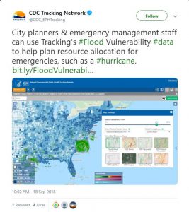
These new content areas allow users to stay informed of environmental health trends and emerging issues. As the recent hurricane season showed us, having up-to-date, reliable information can be key to staying safe. For example, we were able to use the Data Explorer’s radar and flood vulnerability data to keep the public informed and facilitate response planning. (Figure 1)
To access the radar layer on your own, simply navigate to the Data Explorer and follow the steps to select a content area. Once your content area map appears, click the small gear icon in the upper right-hand corner (underneath the green “About Data” button), which will open up the Map Settings. Choose “Current Radar” from the “Select Overlay Layer” dropdown and hit “Close”. Your map will now include the radar layer in addition to your chosen content area!
New capabilities

The Data Explorer allows you to present environmental health data in visually striking ways. Whether you are a journalist wanting to convey national environmental health information to your readers, a researcher looking for validated environmental health data on a particular state, or a curious citizen interested to learn more about your county, our Data Explorer has something for everyone.
We recently added new features that make our Data Explorer even more valuable to users. For example:
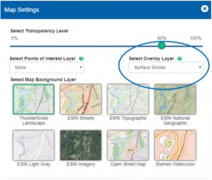
- Wondering how your community might be impacted by wildfire smoke? → View our new wildfire smoke tool or add our predicted wildfire smoke vulnerability layer to an existing map by selecting “Surface Smoke” overlay layer in the Map Settings! (Figure 2)
- Have an eye towards the future of extreme precipitation? → Look under the Climate Change content area to find projected extreme days, intensity, or ratio of snow to rain days and watch the projected timeline progress up to the year 2084!
Whatever content area you choose to explore, our data can be used to inform decision making, keep the public aware of environmental health events, and deliver Better Information for Better Health.
Follow us on Twitter (@CDC_EPHTracking) and Facebook (@CDC National Environmental Public Health Tracking Network) to stay up-to-date on Data Explorer features, national health trends, and more.
Tweet this: “Check out CDC’s Nat’l Environmental Public Health Tracking Program that works with local & state health depts, federal agencies, and nat’l organizations to deliver accurate, current data that is consistently available to you. Go to https://bit.ly/2GsV7x9 #CDCEHblog via @CDCEnvironment.”
Post a Comment